Hiking with Linda - Route Description
March 2003
arrigo@seed.net.tw
INTRODUCTION
Since about three years ago I've been exploring the hiking trails in the range of National Chengchi University (Chengda, 政大), that is, the medium-height mountains to the east of Muzha 木柵.
The highest is variously called Er Ge Shan (二格山 ) or Shih Jian Shan (石尖山 ), 680 meters high; that is at the end of the straight steep main ridge that runs northeast up from Mao Kung 貓空, in back of Chengda, a well-traveled route. But I have found the lower (350 to 500 meters elevation) and less-traveled paths more verdant and more enjoyable to walk.
In fact, I explored a large part of the area in the hills between Muzha (Wen Shan District 文山區of Taipei City, southeast corner) and Shenkun 深坑 (the old town where tourists eat bean curd in all forms, including stinky) in Taipei County. This is an excellent area to hike, because it is easily accessible and well-traveled enough that the trails are fairly clear; you won't get lost, or if you do, farmhouses are not far below. But at the same time most of it feels like jungle untouched by modern industrial society.
ATTACHED mapS:
"Shenkun Hiking", JPEG file 1.2 MB, small area, color with higher elevations in darker orange, and two trails marked, some English added.
PRINT OUT THIS map "Wen Shan Hiking B&W", TIFF file 0.99 MB, large area showing all approach roads, contour map, elevation over 500 M also marked with hatched shading, relevant roads darkened, all Chinese place names, many trails marked.
(註:這兩張地圖為市售地圖,有著作權問題,故未於網站公開呈現)
I even discovered an old overgrown trail winding through jungle ferns and passing abandoned farms, and I cleared it out and marked it with the help of several friends. There is a small waterfall with a pond underneath deep enough to swim in, along the way!
The following is the hike I recommend for a hearty all-day trip (about 4-5 hours walking). It is also possible to take it in two trips, because the trail intersects with a road that crosses over the ridge (at nearly 500 meters elevation), going from Muzha to Shenkun. The intersection is at the Tian Nan Gong 天南宮 (temple dedicated to the teenage warrior San Tai Dze 三太子), where there are also two parking lots and a restaurant. You probably will find you cannot cover more than 1-1/2 km an hour on the steep slopes of Taiwan's mountains, half of usual walking speed on level ground.
This guide also notes where you can branch off for more challenging hikes in the future.
PREPARATIONS: I strongly recommend carrying a backpack, because you will need both your hands on the climb at the beginning; and a long walking stick for the slippery moss-covered stone stairs going down at the end. If the weather is warm, bring a swimming suit and small towel -- for the waterfall pool near the end of the trail, which will be so welcome when you are hot and sweaty. I recommend two bottles of water for a half-day hike, and at least three for a whole day hike.
Also, print out this guide and the B&W map to take along with you. Practical trip times for out-of-shape people are in text. The first part of this hike is well known:
Monkey Perch Trail
From Chih Nan Gong指南宮to Monkey Perch Trail猴山岳 to Tian Nan Gong天南宮 (4.5 km)
PUBLIC TRANSPORT: Take a bus from Chengda to the Chih Nan Gong Temple 指南宮; the 530 (which begins at Gong Guan公館) runs about every ten minutes up Wan Shou Road 萬壽路, and there are also other small buses. It takes less than 15 minutes that way to the parking lot below the temple; then walk up another ten.
Or you can walk up the stone stairs that start on the east side of Chengda, at Chih Nan Road 指南路, Section 3, someplace around Lane 13. The stone stairs are clearly marked with a large stone arch. Figure 45 minutes to the temple, less if you are in very good shape.
圖1:Monkey Perch Climb
It is well worth starting from the Chih Nan Gong ("pointing-south temple") if you have not been there before; it is one of the most famous in the Taipei basin, with about 200 years history. It is dedicated to Lu Tung-pin, one of the eight immortals, a.k.a. Master Ji; at the back of the temple you can see a drawing of the Eight Immortals Crossing the Ocean, newly carved on marble slabs. Master Ji in the center carries a sword. Legend has it that when he arrived in Taiwan he put his first footstep on the mountain in Jingmei, and the second on the mountain here. But be warned, don't come into this temple with a betrothed; Master Ji is a jealous spirit, and he will cause the couple to break up. Married already is okay though.
Start out from Chih Nan Gong Temple: 9 am.
From Chih Nan Gong, follow the paved path out the back of the temple and up to the left; soon you pass another large temple, the Ling Xiao Dian 靈霄殿, and you will connect up with the parking lot above the temples and another access road. Follow this road for a large block until you see on the left small concrete stairs with a green-painted imitation bamboo railing, going up the hill through tea bushes. The stairway is clearly marked with a post, "Hou Shan Yueh猴山岳" (Monkey Perch in my translation), about 1 km (allow 30 min.). This takes you up and over a minor ridge to a tea house, which meets another access road. Walk DOWNHILL (left) on this road about three blocks to a huge white vacation house on the hillside. The Monkey Perch Trail starts at the side of this house; it is well marked with many hiking clubs' tags. The elevation here is about 380M.
圖2:Monkey Perch Climb
EXPRESS ACCESS: Actually, I rather suggest that you take a taxi right to the big white house, from the Zoo or Chengda, and start the fun part right away, especially if you are departing after 11 am. Take Wan Shou Road, pass the Institute for International Relations and a lot of apartment complexes, and turn a sharp left (there is a sign for the "Monkey Mountain range chicken house土雞城)" just a block or two before the lower Chih Nan Gong parking lot. From there you drive up the steep winding road about ten minutes, keeping to the right at two forks. You can't miss the big house. The meter will say NT$130-150, but give the guy NT$30-50 extra for going out of his way.
Target time, start climb up to Monkey Perch: 10 am.
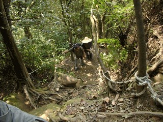
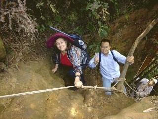
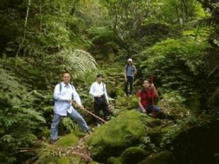
This beginning part of the trail is well-traveled and well-marked, and on a nice weekend there may be a virtual traffic jam. You can see the top looming above before you start; it is 515M. At first you walk in big steps up the steep slope, and later you climb on roots and ropes (PICTURES 1, 2). It takes me 35 minutes with a lot of panting. Because of all the ropes and footholds carved out, it is pretty safe. Children can do it.
圖3:Along the ridge
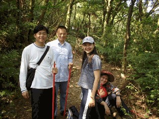
If it is a clear day, there is a wonderful view from the top, in fact all the way to Grass Mountain and Kuanyin Mountain at the mouth of the Tamsui River on the other side of Taipei Basin. Then after rest and water continue along the ridge to the east; the trail is clear and gently rising (PICTURE 3), passing a large tea estate near highest elevation, about 550M.
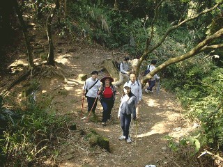
After about 30 min. the trail dips, and there is an intersection (PICTURE 4).
ALTERNATIVE ROUTES, SHORT AND LONG:
TO THE RIGHT (SOUTH), EASY WAY OUT any party poopers would go back down within about 20 minutes to the road that runs up the valley from Chengda (Chih Nan Road Section 3). From there, then continuing up (left, east) that paved road could still take you to Tian Nan Gong 天南宮 with a somewhat easier walk on an asphalt mountain road. You would first pass a cluster of farm houses and shops named Tsao Nan 草楠, and later the road gets really steep as it climbs the ridge.
圖4:Intersection of paths, after passed and looking back. Choice:Party poopers(down), or future Shangrila adventure.
But if you really want to give up, then down (right, west) on the road goes down the mountain. Cut to the right off the road again when you see a path at a small shrine (marked Kai Tien Gong 開天宮 on the map), and there is a large level path beginning there that joins the access road at the back of Chih Nan Gong. So the party poopers could climb Monkey Perch and get back to the bus at the temple in two hours some.
On the road just below where the level path splits off, there is a bus station and toilets, with small bus running in the Chengda direction only twice an hour. Here there is a side road that loops around to Mao Kung, home of tea shops and karaoke restaurants, but you'd have to walk there.
TO THE LEFT (NORTH), SHANGRILA ADVENTURE, at the intersection of the two paths on the mountain ridge, you go down steeply towards Shenkun, and in about half an hour, at 400 meters elevation, you are in a Shangrila forgotten by time. You will come upon a tea estate and rice fields planted by a 60-year old farmer who came there with his father as a child, surname Lin林. Excellent tea can be tasted, surrounded by hand-woven drying baskets; and purchased reasonably. The family lives in a hundred-year house with grass roof, now named a heritage site. You can ask to see the inside, and the hollowed stone water tanks. The Lins will try to keep you there till almost dark with stories of native herbs, but remember, this is Shangrila, and you may have a hard time climbing the rest of the way down the mountain ... allow two hours back down to Shenkun Town ... I found a waterfall someplace up there in the twilight, but I lost it again.
But our current recommended trip does not wander down to Shangrila, save it for the future. Pass the intersection of the two paths, and the slope rises again steeply. After about 30-40 minutes and a lot of winding around on the crooked spine of the last mountain, you will come out on the road -- yes, the same one that goes past Tsao Nan. You are a little above the Tian Nan Gong, which is to the left. (Note by the way that the beautiful path to Er Ge Shan starts across the road.)
It has probably been over two hours, including rest time, since you tackled the Monkey Perch climb. The temple has water faucets, and there are outhouses across the road. Also a restaurant is up there, food not bad. Next part of the hike starts from the parking lot below the restaurant and the outhouses.
Target: arrive Tian Nan Gong at 12:30 noon, leave 1:00
ALTERNATIVE HIKES FROM TIAN NAN GONG: The most common hike from Tian Nan Gong is up to Er Ge Shan, 680 M, and then westward along the top of the ridge on the other side of the valley. Do it on a clear day when the view is spectacular. You can come down from the ridge either fast (to Tsao Nan, 2 hrs.) or after an arduous hike (to Chang Shan Buddhist Temple, 4-5 hrs). Refer to map.
There is a fork in the path after you have already climbed a hundred meters (about 50 min.) and are almost below the final peak of Er Ge Shan. The location has a rustic shelter with vendors who sell sweet bean soup (綠豆湯) and cold beer, with access by a small road that connects to Bei Yi Highway (北宜路) a long ways away. The right fork goes up to Er Ge Shan, as described. The left fork goes eastward along the top of the even more jagged razor-back ridge through Bi Jia Shan筆架山 (585M), at least five hours walk to Shi Ding石碇, and almost no alternative trails down until the end. Don't depart later than noon. Take bus 666 back from Shi Ding.
Linda Road
From Tian Nan Gong天南宮 to Shen Kun深坑, easy hike, 4 km.
Target departure time, 1 pm (up to 3 pm okay)
This trail was originally named (by me) Karla Path卡拉步道 after the young Canadian woman who was with me when I discovered the crucial connecting section of the route, but my friends remember it after me. It is marked with purple spray paint and purple cloth strips (headbands) that were left over from anti-nuke movement activities. Linda Road is an easy two hours' jaunt or less walking time. But smell the flowers along the way.
The spray paint begins at the side of the parking lot, where a path leads down to a few farm houses. We marked it "LINDA ROAD to Shenkun" in light purple.
OTHER PATHS: There is another path at the other end of the parking lot, beginning at a gap in the concrete wall, which also goes down to Shenkun, steeply by a less scenic route, passing below a modern high rise home for the aged perched on a cliff. The path is marked by hiking club flags, but somewhat overgrown. It does pass some spectacular rock formations carved by a stream.
圖5:Down to the mossy brook, then up again.
Go down through the courtyard of the lower farm house, down to the rough stone bench, past the little barking dog with long white hair and the chickens. Once you spot the purple markers here, the rest is easy. If the farmer tells you there is no through path here, tell him you are going to "Nan Bang Liao 南邦寮", and he will know you know where you are going.
Another 20 meters down, and there is a little stream that waters the farmer's terraced fields. Cross the stream, and the wide shady path stretches out, winding along the hillside, gently rising and falling. Around a hill, past a grave named "Gao高" (高媽墓) and a small tea garden, and then there is another stream of pure waters tinkling (depending on recent rains) over mossy rocks. This is one of the most beautiful spots on the trip (PICTURE 5).
圖6:Partly-cleard sunlit area as you pass over the hill at 440M, then down again.
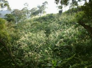
Then the path rises again gradually for a few dozen meters elevation, up to 440 M according to my altimeter. This is maybe 25 minutes after you left the parking lot. You come out onto a hilltop area where the trees were cut for charcoal and the big woody ferns were cut for orchid plant bases (PICTURE 6). There is a fork in the path, and you turn down to the left; it is well marked with purple cloth strips.
Nan Bang Liao, abandoned house
After another 15-20 minutes, and crossing another small stream with the remnants of a water catchment where farm women washed clothes and vegeTABLEs in the distant past, you come to a few stone posts standing among thick vines. This is all that remains of Nan Bang Liao, a cluster of three houses that shows on the 1904 Japanese cadastral maps, the first detailed mapping, but is now merely a name on the paper of modern maps. The pioneering family, named Huang黃, lived there for three generations; the third generation Huang, now in his late 60's, was the last to abandon the houses in the late 1960's when electrification came to villages at lower elevations. He used to grow orchids and carry them over the hills at night to sell at Chih Nan Temple. The family drank the water from the trickle of the stream; he says it is good water. Now he just comes up to harvest the thick bamboo shoots, Ma Sun, and also for the pomelo (grapefruit) trees. There is a thicket of wild ginger flowers next to the ruins. You may notice how the steep slopes were only barely habiTABLE because of the labor of the farmers, with carefully shaped stone supporting-walls for the paths and the bamboo thickets, stonework now barely visible under the fallen leaves.
Target: 1:45 pm at Nan Bang Liao
Through the Jungle
A block past the tumbled-down house, you must be careful to turn right and descend again steeply, not go up to more bamboo groves. The turn is marked with purple spray paint on rocks and bamboo sticks. But it may not be obvious because in turning right you leave the stone-lined paths of the farm area, and the path is very rough and steep for half a block, before it levels out again, broad and pleasant like before, and probably ringing with the shrill calls of birds and frogs, especially as the afternoon sun shines up the narrow valley and filters through the fern trees. Try to catch a glimpse here (at about 300 M elevation) of the barren rocky crags of the razor ridge above on the other side of the valley (550 M elevation); that is the ridge stretching from Er Ge Shan 二格山 (680 M) to Bi Jia Shan 筆架山 (585 M) (Brush Holder Mountain, recognizable by the double point at the top). This section of the path, beginning from Nan Bang Liao, takes about 20 minutes.
It ends up in a big clump of bamboo where it may not be easy to see the continuing path. That is because the wild taro patch just beyond to the left (and a meter higher in elevation) grows over so quickly in the muddy soil here, even after we clear the path. Look for the purple markers overhead in the trees. But only fifty feet or so through the taro patch, and the path is fairly clear again, and much is paved with rough stone steps, descending gently relative to Taiwan's precipitous slopes, looping around the hills. However, the path is narrower and more grown over; this is the section of about one kilometer, from Nan Bang Liao to the Chen farm, that I had to sleuth out and clear with machetes in order to join the paths more-used by the farmers on the high and the low elevations. In this section also the feeling that you are trekking through the jungles of deepest Africa is palpable. Enjoy it, don't walk too fast; this section is only about 20 minutes walk. Then you suddenly exit into the sunny bamboo groves of the Chen farm. You can see the buildings level ahead.
Target: 2:15 pm at Chen Farm
The Ghostly Model in the Bamboos
圖7:Ghostly model with purple neck scarf, near the turn in the bamboo grove at Chen farm.
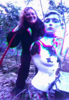
The Chen陳 farm has several abandoned stone buildings with brick walls perhaps nearly a hundred years old, but the farmers cook here when they come to work, there is a tin-sided storage shack, and a hose runs clean water into a silted-up fish pond. Originally there were rice fields in front of the house, which sits on a broad shoulder of the mountain with a wonderful view. It is worth noting the fruit trees and flowering plants beyond the stone planks bordering the buildings. However, after you have seen the old stone farm implements, turn around and go back to the bamboo grove where you exited the jungle, and follow the path downward. Of all surprises, there is the bust of a shop-window model set next to the path in the bamboo grove, either to scare birds or to scare off people with her ghostly white face (PICTURE 7). I put a purple headband on her brow, and later also dressed her in a scarlet T-shirt to replace the tatters.
From here the path is clear and closely follows the contours of the waterway that is far below, invisible. But the path is steep and set with rough stone stairs that can be slippery when mossy and damp. If you did not carry a walking stick before, try to find one among the old cut bamboo around the model. This is an imperative. Ideal length is up to your nose, so you can stabilize yourself several stone steps in advance.
After about 20 min. walk down past old taro terraces now flowering with wild ginger blossoms fluttering like fragile white butterflies (from July to November they grow in profusion and exude a light sweet fragrance), there is an earth god shrine on the left. The old stone shrine under a huge rock outcropping is charming, though roofed with a newly-replaced and tacky red metal canopy. Pause here for a moment.
Target: 2:45 pm at Earth God Shrine
圖8:Almost to the waterfall
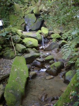
Fifteen feet down the stone stairs from the shrine, see a big white plastic pipe partly exposed in the dirt. Here there is a small unpaved path that goes towards the stream, facing upstream (i.e. turn right sharply). Less than 10 minutes along this side path, and you will see the stream flowing through clear pools and tumbling over water-smoothed rocks (PICTURE 8). The side path ends at a small paradise in the jungle: a thirty-foot high rock face, a spout of water coming down between huge boulders, and a wide pool over four feet deep at the back (PICTURE 9). If a typhoon has just passed over, the water will be deeper, and the cascade almost too strong to stand under.
There is no population currently living in the entire catchment of this stream, and only a small cultivated area of bamboo, so I often fill my drinking water bottles here. It is possible to keep forging up the stream by clambering up the barely-visible path around the left of the pool. There are interesting rocks and pools one level above, but after that the stream levels out somewhat, and if you rock hop along the stream for about an hour, you will see abandoned farmhouses and terraced fields grown over with tall grass. But that is a trip for another day.
圖9:Small waterfall,pool 4 ft. deep in middle.
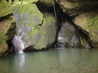
The pool is a refreshing spot to play in the water and lounge and chat on a hot summer day. Elevation here is about 220 M. At about 3-4 pm the slanting sunlight lights up the waterfall, the best time to be there.
Back at the earth god shrine, it is at least a 20 minute walk down more treacherously-slippery stone stairs before you are back on an asphalt road, so don't get caught past daylight. In one place the steps are yard-wide stone planks that seem to have been hewn out of nearby bedrock: a Herculean task. When you are finally at the exit point, a gravelly driveway to the road, go look at the stream again and see on the other side a wall of huge boulders that were neatly piled to create a terrace for farming banana and taro. Again, amazing labor for a pre-industrial society.
Target: 3:30 - 4 pm at Bottom of Linda Road
On the road, you are still a ways from public transport. The white concrete wall by the road has been spray-painted "Linda Road, to Tian Wang Gong天南宮" in purple, so if you came by two vehicles you could leave one there. (This is the same road that goes over the mountain at Tian Wang Gong; it is a 10-15 minute drive down (6 km), with several big loops, to the bottom of Linda Road.) But it's not really necessary to have wheels, because 35 minutes brisk walk downhill from the bottom of Linda Road will bring you to the center of Shenkun Town.
At Shenkun Town
Shenkun is the town where the tourists flock on weekends to eat bean curd in all forms, zhungdze綜子 (sticky rice wrapped in bamboo leaf triangles), and home-made popsicles (mulberry flavor is local). So it is very nice to end your long hike here and immediately feed your hungry stomach. The best delicacy is the bean curd roasted with barbecue sauce and peanut powder; most is stinky (fermented), but there is also a stand right next to the big tree that sells non-fermented (NT$20). The sit-down restaurants all up and down the historic tourist street are mostly priced about the same, so allow NT$150-200 per person to eat well.
PUBLIC TRANSPORT: Out on the main street, you can take Bus 660 west to get to the Muzha Station of the MRT Brown Line, or go on to Jingmei 景美on the same bus. There is even a Bus No. 6 which goes east over the hills fast to Nankang (with stops at Academia Sinica), but it only runs about once an hour; last bus passes Shenkun at 5:55 pm (see schedule on the sign; add 25 minutes on to Zoo departure). If you walk west from the big tree ten minutes (or take a bus three stations), you get to the beginning of the Bus 236 route, which runs every five minutes and goes quickly to the Zoo and National Chengchi University, and then on to Gong Guan公官 (National Taiwan University台大) and Roosevelt Road.
ALTERNATIVE, HIKE UP: Start hike from Linda Road, Shenkun深坑 and on to Chih Nan Gong指南宮
Of course you could start Linda Road from the bottom (though it feels best to jump in the cool water at the end). If you did start from the bottom of the trail, near Shenkun, you could get to Tian Wang Gong in less than two hours, and then pick up the road there and walk on asphalt and level path over the summit of the ridge and down to the back of Chih Nan Gong in another easy hour (part of the party poopers' route described under Monkey Perch hike)
FIND TRAIL ACCESS FROM SHENKUN: The main thing is to find the beginning of the trail. Note, if you look on a map, that the mountain road to the trail is a continuation of the Zhung Cheng Bridge 中正橋that crosses the river just out the back of the historic old center of Shenkun, marked by a huge tree. There is a new highway parallel to the river, south of the old town. The narrow entrance to the mountain road may be hard to spot between the new gas station and the showy betel nut stand on the highway, but if you go straight from the bridge you can't miss the intersection. There are several signs in Chinese saying "To Tian Nan Gong 往天南宮." Once on the mountain road, you go gently straight up the valley almost two kilometers with the Shenkun stream on your left; the first hairpin turn to the right is where Linda Road begins, as described above, with purple markers.
Please drop me a note and tell me how you find the hikes, and how useful the guide!
Linda, arrigo@seed.net.tw